April 2, 2009
Attention on deck! Daily photos are no longer being updated on The Dinghy Dock...

Visit my other blog,
"ORIENTAL DAILY PHOTO"
for my almost daily photos of Oriental/Pamlico County/ Local Waterways
...

Thanks for coming aboard!
-Capt. Ben
Showing posts with label weather. Show all posts

Thursday, September 25, 2008

9.25- Skywatch Friday - River of Light

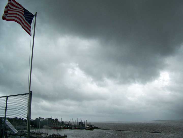
A shrimp trawler rides a river within a river... a river of light in the cloud shadows
on the Neuse River... into Oriental Harbor under skies darkened by extratropical storm 94L

Click on picture or here for full size

Today's SWF picture was taken about 1:00 p.m. local time, Thursday Sept. 25, from the Lou-Mac Park fishing pier on the Neuse River, facing southwesterly.

Extratropical storm 94L is quieting down after bringing heavy winds and a bit of rain to eastern North Carolina overnight. Rainfall in Oriental was measured at one half inch, but some gusty winds in the 40 mph range tore through town last night.

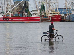
The prevailing northeast winds brought in by this storm over the past three days caused an unusually high wind tide along the coast, no exception for Oriental...
See my posts from earlier today and yesterday for views of the risen waters: scroll down
or click here

The waters rose a bit more last night, but have been dropping steadily this morning.

The center of the storm is about to go ashore near the North Carolina-South Carolina border, and should quickly dissipate, though we may be in store for more rain over the next few days.

As the remnants of the storm move up the coast, the wind will veer, and the high waters will be blown back out into Pamlico Sound.

Read more about "L94" on WeatherUnderground at Jeff Masters' Wunder Blog.

See radar images of L94 from NOAA.
I look forward to seeing the other Skywatch pictures from around the world on the other SWF sites listed at:


-30-

9.25- Why don't you kids go play out in the street?


Kids playing on "boogie boards" in the wind-tide-inundated portion of Hodges Street.


The water is going down today as 94L approaches the South Carolina-North Carolina border and winds down a bit after a night of gusty winds in the 20-40 mph range.

These three kids were enjoying the "Hodges St. Beach"... a foot or more of water has covered the street since yesterday (see yesterday's post, below)

-30-

Wednesday, September 24, 2008

9.24- "Slow No Wake"

A driver ignores the "No Wake Zone" sign posted at the Hodges Street causeway, which was inundated by rising "wind tide" waters as a continuing Nor'easter pushes Pamlico Sound waters all the way up into Raccoon Creek.
(click on picture or here for full size)


... But of course this is not an official town of Oriental sign...

These three notorious pranksters (identities obscured) were photographed in the vicinity of the sign soon after it appeared... one of them carrying a roll of duct tape...
(click on picture or here for full size)


Sandy (on right) rescued the Farmer's Market signage from the rising waters covering the Farmer's Market area,
Melinda (left) and Sandy then stored the signs in the "Witts End" building, where they will be marginally safer from floating away...
(click on photo for full size)


Town Dock, also on the Hodges' St. causeway, was crowded not with boats, but with "street-gulls" who were enjoying undisturbed (mostly) access to the dock and to the 18 inches of water covering the roadway... Jack (the canine), who normally claims control of the centerline of Hodges St. by lying down on it, decided to let the gulls know just whose house they were in:


The seagulls adjusted to the unfamiliar sight of water-covered Hodges St. by gravitating towards the more familiar...

The mural on the side of the Garland Fulcher Seafood Market building... perhaps they were hoping some by-catch would be tossed from the "Brooke-Morgan"...


OK, here is the artsy shot of the day... You know it's artsy because it's monochrome... for full artsy effect, click on picture or here for full size:


Thanks to the Nor'easter, Capt. Ben didn't even need the dinghy to get out on the water today... the Dinghy Dock itself did the job nicely!


-30-

Saturday, September 6, 2008

9.06- Hanna aftermath

Electric Co. vehicles and line workers assembled under clear skies and a half moon in the parking lot at Mac's gas station as the sun sets.

Tropical Storm Hanna came through Oriental as dawn approached this morning, bringing 20-30 mph winds from about 2:00 a.m. through 8:00 a.m.

From about 8:00 a.m. to 10:00 winds were in the 30-40 mph range, with reported gusts near 60 mph. After 10:00 a.m. it became a beautiful clear day with 5-10 mph winds the rest of the day.

No flooding overnight, no storm surge, no heavy rains, and winds similar in strength to common thunderstorms in the area, though the winds persisted at strength for longer periods of time.

The storm did knock out power to the entire town for a few hours this morning, with intermittent power outages throughout the day as "Progress Energy" crews made repairs around town.

All in all, Hanna was a lot of not much around here. Should be a nice day for sailing tomorrow, and I hope to be out, either in the Bauer Classic 10 dinghy or crewing on my neighbor's Catalina 25.

Ike looks to be headed for FL and the Gulf, and Josephine appears to be petering out. It will be nice to not have everyone talking hurricanes 24/7 around here, as they have been for a few days now.

-30-

Friday, September 5, 2008

9.05- SkywatchFriday - Here Comes Hanna!


About 20-25 mph winds buffet the flag on top of the Hwy. 55 bridge as an outer rain band of Tropical Storm Hanna crosses over the Neuse River and Oriental at about 2:30 p.m., Friday September 5.

An hour and a half later (about 4:00 pm) , as I am writing this post, the sun is out and large puffy cumulus clouds are zipping over us, headed westerly.

All around town boats have been pulled, lines have been doubled, lawn chairs put away or set upside down, a few windows have been boarded, and the picnic benches at Lou-Mac Park have been lashed to the old live oak tree.

Now we wait. I don't know if I'll be able to get any pictures of the scary stuff, since it will be coming in after dark. I'll add more photos to the slide show, above, if I do get any more.

See more views of the heavens from around the globe at:
-30-

Thursday, September 4, 2008

9.04- Preparing for "Hannah"... and "Ike"... and "Josephine


Capt. Dave removes the canvas from the "Hirondelle" in preparation for approaching tropical storm Hannah.


A beautiful, calm clear day here in Oriental... perhaps the proverbial and literal "calm before the storm." Many local sailors and stink-potters are making preparations for some potentially nasty weather.

As Hannah approaches the East Coast, many local sailors are, like Capt. Dave, removing the canvas from their boats and adding extra lines in preparation for high winds.

The Wildlife Boat Ramp is also busy as owners of trailer-able sailboats and power boats haul them out to stay on dry land for a while as a string of hurricanes and tropical storms wander in our direction. Local boat yards are also putting many boats on the hard today. No doubt all will be doing the same all day tomorrow.

Capt. Dave will be watching NOAA, WeatherUnderground and other sources of hurricane/tropical storm info as the three storms approach, and is beginning to think about finding a good "hurricane hole" in which to anchor Hirondelle if things look particularly nasty for either of the next two.

According to NOAA, we can expect a good steady 40 knot easterly winds with 50 + knot gusts by 8:00 pm tomorrow night, with hours more of the same to follow.

That wind will no doubt bring rising wind-tides, which Local Knowledge says will exceed 4 feet, enough to cover Hodges St. at Town Dock, in front of The Bean, but not much more.

All day Saturday the continuing 40 + knot winds will swing across to southerly and end westerly, dieing off precipitously the more westerly they become. By 5:00 pm Saturday, winds will have fallen to below 20 knots westerly. According to NOAA...We shall see.

My brother, "Cabin Boy" Fred has successfully made it back to New Orleans from his brief (3 day) and agonizing exodus to Memphis (where he sat in on a gig playing his newly-acquired Mexican made fender copy guitar} after the Gustav scare.

-30-