April 2, 2009
Attention on deck! Daily photos are no longer being updated on The Dinghy Dock...

Visit my other blog,
"ORIENTAL DAILY PHOTO"
for my almost daily photos of Oriental/Pamlico County/ Local Waterways
...

Thanks for coming aboard!
-Capt. Ben
Showing posts with label sailing. Show all posts

Wednesday, October 22, 2008

10.22- Garbacon Shoal Marker


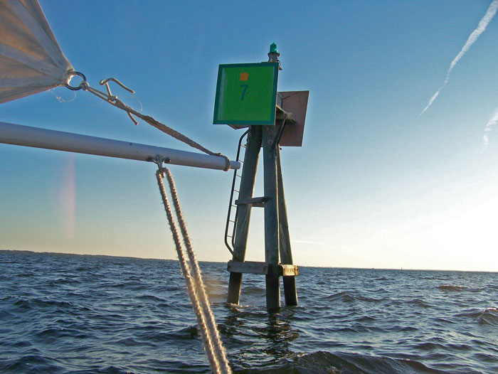
Neuse River Marker No. 7, a.k.a. Garbacon Shoal Marker,
as seen from the Bauer 10 dinghy.

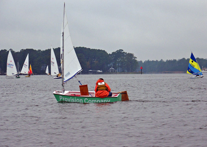
Today I sailed the Bauer 10 out to Oriental Marker No. 1 to try to get some pictures of the weekly Wednesday night sailboat race. Only three sailboats showed up, so I didn't get any impressive shots (I was hoping for more boats).

As the boats sailed off for the first mark on the informal race course, I decided to follow along for a while. I saw the boats rounding the first mark (Garbacon Shoal) and decided to go at least that far.

This is the farthest I have sailed the dinghy out on the river, so as I rounded the marker I snapped this picture for proof/commemoration.

In the foreground you see the boom, the tack of the mainsail and the mainsheet. The whispy threads you see flowing from the mainsail act as my anemometer and tell-tails.

As I reached Garbacon Marker, the three racers were approaching the Adams Creek Marker a few miles downwind. The sun was nearing the horizon, so I decided one leg of the race was enough for me.

As I sailed back, the sun set and the wind died... I mounted my navigational lights and slowly sailed back as the temperature began falling considerably. Fortunately I brought some layers to put on.

The whole round trip - slip to Garbacon and back to slip - was just under 6 statute miles, and I covered it in about one hour and forty minutes... not bad considering the wind died off so much on the way back.

My route today (8.9 stat. miles) is shown by the red line on the map below...

the yellow line is the approximate route of the Wednesday evening races (about 8.25 stat. miles):

View Larger Map

Sunday, October 19, 2008

10.19- Jib testing


Yours truly buzzing Lou-Mac Park while sailing on the Neuse River(Oriental Marker #1 in the background)

Today I went out to test the new jib foresail Capt. Dave and I rigged for the Bauer 10 Classic dinghy. I sailed out of the harbor to Oriental #1, then tacked up into the North wind to reach Lou-Mac Park. After buzzing the park I sailed out to Whittaker Creek markers #1 and #2, then back to the harbor.

Winds were in the 10-15 knot range, out of the North, so both the rig and myself got a good work-out. The jib has a number of issues to be solved... the most annoying is that when tacking, the sail tends to foul on the boom (which protrudes up to one foot forward of the mast) and the jib sheets keep getting tangled on the forest of cleats that now inhabit the lower mast.

Early indications are that the jib improves the dinghy's windward ability, but more testing is required to confirm. Still can't quite sail close-hauled, though.

I am confident that the Bauer is sailing faster on all points of sail with the added jib, the most noticeable difference being on beam reach and close reach.

The best thing so far about having a jib is that I can go "wing-and-wing" while running downwind... While running wing-and-wing today I hit a steady 4.0 + knots, maxing out at 4.5 knots! I have hit 4.7 knots before, with only the mainsail, but in heavier winds.

The mast is developing a pretty serious crack, and I don't know how much longer it'll last in winds like today's. Probably time to build a new mast, and re-think the running rigging.


-30-

Saturday, October 18, 2008

10.18- Green's Creek Challenge


An Optimist dinghy heads down-wind towards the finish line in today's Green's Creek Challenge race, while Laser and Sunfish boats round Dewey Point towards the Smith's Creek race marker.

A cool rainy day for today's Green's Creek Challenge, an annual sailboat race for boats under 20 feet sponsored by the Oriental Dinghy Club.

The race route began in Oriental Harbor, passed under the bridge, up Green's Creek, back down to Dewey Point, up Smith's Creek and back to the start.

The ODC had not posted results as of this writing.

Here are some more shots from the race:


-30-

Thursday, October 16, 2008

10.16- "Skywatch Friday" - Sunrise & Moonrise


Sunrise over the Neuse River

Yesterday I was out boating before dawn... then again out boating after sunset. Two different trips.

The sunrise series above was taken from Captain Keith Bruno's Carolina Skiff as we headed down river to pull Capt. Bruno's gill-nets for fish.

You can meet Capt. Bruno, a really interesting guy, in Part One of my feature essay on Bruno, posted October 14 (scroll down to posting, or click here)... more of the essay is coming soon in Part Two...and maybe even Three.


Later on yesterday, I rowed across the glassy windless waters of river, in the Bauer 10, out to Oriental Marker No. 1, where the "Coriolanus" was drifting around for a Hunter's Moon watching party (see right). There was so little wind that even without an anchor, Coriolanus stayed within 50 yards of the same spot for about two hours.


Before I rowed out, I got the below picture of the moon rising over the river from the end of the Lou-Mac Fishing Pier.

Another dinghy-rower appears in the lower left, going into Whittaker Creek (you can tell it's Capt. Jesse by the bent oars!!)... the familiar Whittaker Point on the left... and a lone sailor trying to find wind on the right side of the picture:


While I was happy with the picture I got of the Oct. 14th Hunter's Moon, I was disapointed to have missed it coming up over the horizon... Then I learned from University of Texas' "Earth and Sky" that the Hunter's Moon was on the 14th AND the 15th, so I went out yesterday before moonrise and got the following series of the second night of the Hunter's Moon rising:


HAPPY SWF EVERYONE!
I look forward to seeing the other Skywatch pictures from around the world on the other SWF sites listed at:
-30-

Saturday, October 4, 2008

10.4- Slow Solos

A number of sailboats in today's annual Neuse Solo Race were "wing-and-wing" in what passed for the "down-wind" leg of the race between the Garbacon Shoal marker and the Adam's Creek marker on the Neuse River.

(Click on picture or here for full size)

Solo sailors in today's Neuse Solo Race might've wished they had someone else on board to complain to about the lack of wind during most of the race.

I overheard a number of gripes from the fleet over the VHF while I too was attempting to sail on the Neuse.

One complainant broadcast that he was cruising at all of 0.3 knots... another captain responded he wished he had that kind of speed.

A number of captains repeatedly complained about the wakes from one chase boat interfering with what little momentum their sailboats achieved.

As the race time ran down with no boats nearing the finish, an increasing stream of captains well back in the pack called in to report they were abandoning the race... no doubt interested in getting back to the Tiki-Bar for post-race festivities.

The Committee Boat let it be known that the race would be called at 5:00 pm and finishing order would be based on the boats' positions at that time. No word yet on the winners.

The boats in today's photo are headed roughly towards the camera position, and appear "hull-down"... their hulls are not visible. The boats are about 3 to 4 miles away, the camera is only about one foot above the surface of the river, and the hulls of the boats probably stick up about four or five feet above the water... so the earth's curvature can account for some of the invisibility

... The BIG factor, however, is the REFRACTION OF LIGHT, creating an INFERIOR MIRAGE (the same thing that creates apparent "water" or "oil slick" near the horizon on highways or deserts).

The refraction caused as the light travels from cooler air to warmer air near the surface causes the light to curve away from the earth. Result is that you can't see what is actually in front of you, but you can see two of what is above you... the top "right-side-up" image of the tops of the sails is light traveling directly from the sails into the camera (or eye) while the bottom "upside-down" images are caused by light from the same objects traveling in a concave curve, first down toward the earth then back up and again into the camera (or eye). The light from the lower masts, trees and sails never reaches the camera, since it is also curving down towards the earth and then away from the earth and above the camera.

Click on the full size photo and you can really see the effect of refraction on the boats on the right side of the picture... You can see where the upright sails and trees of the shoreline meet what appears to be their reflection extending upside down from the bottom. This is a common optical illusion on the water: it makes distant shorelines, boats and other objects on the surface appear closer than they actually are (contrary to side-view mirrors on cars) because the refracted image makes it appear about twice as large.
-30-

Sunday, September 14, 2008

9.14- Parade of Shrimp Boats


Four commercial trawlers (shrimp-boats) leaving Oriental Harbor as weekend shrimping curfew ends.

I was out sailing on the Neuse River in the Bauer dinghy today when these four shrimp-boats left Oriental harbor and headed down the Neuse River for a new week of shrimping.

There is a shrimping curfew from Friday midnight to Sunday noon, so on Sunday afternoon most of the commercial shrimp boats leave their weekend berths at Garland Fulcher Seafood Co. and Point Pride Seafood Co. to go out shrimping.

I was sailing near Oriental Marker #1 when these four trawlers started coming out. In order of departure (and in order of the slides above), they were:
  • "Goldie Marie" - 73 foot, 93 tons, owned by Chris Fulcher
  • "Capt. Cecil" - 75 foot, 130 tons, owned by Sherrill Styron
  • "Emily Brooks" - 73 foot, 108 tons, owned Sherrill Styron
  • "Amanda Ashley" - 73 foot, 92 tons, owned by Forest H. Williams, Sr., Grantsboro NC
Mr. Chris Fulcher owns "Point Pride Seafood," while Mr. Sherrill Styron owns "Garland Fulcher Seafood," which can be a bit confusing at first.

The late Garland Fulcher was the local fishing baron and Chris Fulcher's father. Sherrill Styron was Mayor of Oriental for 24 years, and is now a Town Commissioner. I don't know anything about Mr. Forest Williams of nearby Grantsboro.

"Point Pride Seafood" is on the Eastern side of Raccoon Creek (where you see the trawlers in the banner/title photo at the top of this page), while "Garland Fulcher Seafood" is on the Western side (not visible, but to the left in the banner/title photo at top of page).

"Point Pride Seafood" sits on a property with a very long and interesting history in Oriental... the point of land it is on, at the confluence of Raccoon Creek and the Neuse River, was known as "Chadwick Point" in the late 19th century, and was home to two lumber mills at the time the town was chartered in 1899... one of the mills was owned by Robert Midyette, who in 1873 purchased the 350 acres of land on which the town was founded.

(For some reason, local lore credits Robert Midyette's nephew, "Uncle Lou" Midyette -- half of the namesake of "Lou-Mac Park" -- as the "founder" of Oriental, but my research indicates that Robert Midyette was the actual owner of the land and the real mover and shaker behind the town's creation)

"Raccoon Creek" was also known as the "log pond" when the Chadwick Point lumber mills were operating because "rafts" of logs which had been cut down farther up the local creeks were floated down to Raccoon Creek where they floated while awaiting milling at the Chadwick Point mills.

The Chadwick Point land was eventually purchased by the "Oriental Bulkhead and Improvement Company" in a fascinating (and ultimately disastrous for the OBIC) land development scheme, about which I'm sure I will explain more in a future posting.

Anyway, enough about Oriental history... today it looked like "Goldie Marie" was going shrimping on Garbacon Shoal, just across the Neuse River from Oriental (in the last picture, you can see Goldie Marie in the distance, turning off to starboard), while the others proceeded farther down the Neuse and possibly into Pamlico Sound.
-30-

Wednesday, September 3, 2008

9.03- Sailing with the Dolphins


Dolphins (probably bottlenose) surface while hunting in Camp Creek.

While out sailing in the Bauer dinghy, I found these guys swimming in circles around the mouth of Camp Creek, where it merges with Smith Creek before flowing out into the Neuse River. I am guessing they were hunting... the creeks are full of shrimp and minnows of all sorts.

The dolphins were swimming in a wide circle around the entire mouth of Camp Creek, and I had little luck keeping up with them in some fickle and weak winds. I also had little luck with the camera, as it is a tad difficult to get decent shots while trying to hold the tiller and the mainsheet at the same time.

After doing my best with the camera for a while I set it aside and relaxed into the boat, sailing around and listening for the dolphins blowing as they surfaced...

"poof... poof... poof" would alert me to their surfacing, and I could turn my head in time to see them arching back down into the waters, and others coming to the surface behind them... just like in this short video I was also able to capture:


-30-