April 2, 2009
Attention on deck! Daily photos are no longer being updated on The Dinghy Dock...

Visit my other blog,
"ORIENTAL DAILY PHOTO"
for my almost daily photos of Oriental/Pamlico County/ Local Waterways
...

Thanks for coming aboard!
-Capt. Ben
Showing posts with label water. Show all posts

Saturday, December 27, 2008

12.27- Paradise Cove Boat Ramp

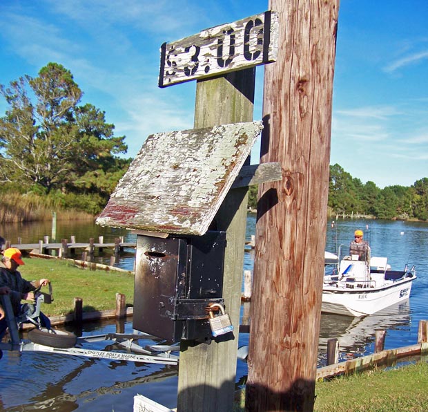
Catfish "honor box" (under surveillance) at Paradise Cove Marina's boat ramp
(Click on image or here for full size)


Today I drove my visiting brother Fred around for a tour of Pamlico County.

Found this catfish drop-box for ramp fees at the Paradise Cove Marina boat ramp. I was surprised to see that the catfish itself is approved for use as a U.S. Postal Service delivery box (before it was modified, at least.)

Paradise Cove Marina expanded it's marina this year... The marina also boasts a fine bar / deck, open weekends during the season, and available for private parties.

Great place for a sunset and refreshments during the season... but remember to bring some DEET!

Small boat ramp, fee is $5.00.

Where is Paradise Cove Marina, NC?

View Larger Map

-30-

Wednesday, October 29, 2008

10.29- Foreign Yacht


Yacht cruising down ICW between Garbacon Shoals and Whittaker Creek on the Neuse River
(click on picture or here for full size)

I'm guessing this is about a 100 foot (or more) yacht, cruising at full throttle down the ICW as it passes by Oriental in the Neuse River... probably headed for Beaufort, where these big guys like to tie up.

The yacht is flying a foreign flag off the stern (with a "courtesy" small U.S. flag flying amidships)...

I have looked through some on-line flag directories, and all I can guess is that it is the flag of the Marshall Islands.

If you can identify the flag, please drop me an comment/ahoy at the end of this post... You can click on the picture above for a full size view.

Whittaker Creek marker No. 2 is on the right side of the picture, while a sailboat just visible on the left heads towards Whittaker Creek.


-30-

Monday, October 20, 2008

10.20- "Day's Landing"


"Honor box" at the Days Landing boat ramp on Ball Creek.
Today I went out exploring the nearby Whortonsville and Florence areas of Pamlico County, looking for creek entrances for some possible kayaking.

I found these three camouflaged anglers taking their Carolina Skiff out at "Day's Landing" on Ball Creek, which runs into the Bay River near Florence.

Don't ask me why the anglers were all wearing camo... I cannot imagine that it fools any fish, and none of these guys had guns, so they weren't hunting... and anyway they have made no attempt to disguise their Carolina Skiff.

I will chalk it up to a general outdoorsman lifestyle, which I admittedly know little about except for an occasional trip to Bass Pro stores, where camo certainly appears in abundance.

This seems a good place to put in a kayak for a paddle around Ball Creek, Bonner Bay, Spring Creek and Long Creek.

... And from the looks of the sign, Day's Landing has not raised their ramp fee in some time!

Explore Ball Creek ("Day's Landing" is at the map marker), Bay River, Bonner Bay etc. on Google Maps:

View Larger Map

-30-

Saturday, October 18, 2008

10.18- Green's Creek Challenge


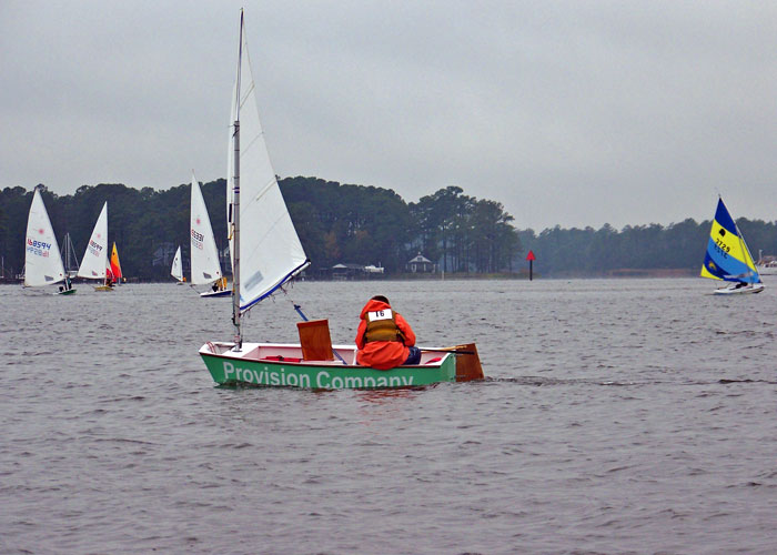
An Optimist dinghy heads down-wind towards the finish line in today's Green's Creek Challenge race, while Laser and Sunfish boats round Dewey Point towards the Smith's Creek race marker.

A cool rainy day for today's Green's Creek Challenge, an annual sailboat race for boats under 20 feet sponsored by the Oriental Dinghy Club.

The race route began in Oriental Harbor, passed under the bridge, up Green's Creek, back down to Dewey Point, up Smith's Creek and back to the start.

The ODC had not posted results as of this writing.

Here are some more shots from the race:


-30-

Thursday, October 16, 2008

10.16- "Skywatch Friday" - Sunrise & Moonrise


Sunrise over the Neuse River

Yesterday I was out boating before dawn... then again out boating after sunset. Two different trips.

The sunrise series above was taken from Captain Keith Bruno's Carolina Skiff as we headed down river to pull Capt. Bruno's gill-nets for fish.

You can meet Capt. Bruno, a really interesting guy, in Part One of my feature essay on Bruno, posted October 14 (scroll down to posting, or click here)... more of the essay is coming soon in Part Two...and maybe even Three.


Later on yesterday, I rowed across the glassy windless waters of river, in the Bauer 10, out to Oriental Marker No. 1, where the "Coriolanus" was drifting around for a Hunter's Moon watching party (see right). There was so little wind that even without an anchor, Coriolanus stayed within 50 yards of the same spot for about two hours.


Before I rowed out, I got the below picture of the moon rising over the river from the end of the Lou-Mac Fishing Pier.

Another dinghy-rower appears in the lower left, going into Whittaker Creek (you can tell it's Capt. Jesse by the bent oars!!)... the familiar Whittaker Point on the left... and a lone sailor trying to find wind on the right side of the picture:


While I was happy with the picture I got of the Oct. 14th Hunter's Moon, I was disapointed to have missed it coming up over the horizon... Then I learned from University of Texas' "Earth and Sky" that the Hunter's Moon was on the 14th AND the 15th, so I went out yesterday before moonrise and got the following series of the second night of the Hunter's Moon rising:


HAPPY SWF EVERYONE!
I look forward to seeing the other Skywatch pictures from around the world on the other SWF sites listed at:
-30-

Saturday, October 4, 2008

10.4- Slow Solos

A number of sailboats in today's annual Neuse Solo Race were "wing-and-wing" in what passed for the "down-wind" leg of the race between the Garbacon Shoal marker and the Adam's Creek marker on the Neuse River.

(Click on picture or here for full size)

Solo sailors in today's Neuse Solo Race might've wished they had someone else on board to complain to about the lack of wind during most of the race.

I overheard a number of gripes from the fleet over the VHF while I too was attempting to sail on the Neuse.

One complainant broadcast that he was cruising at all of 0.3 knots... another captain responded he wished he had that kind of speed.

A number of captains repeatedly complained about the wakes from one chase boat interfering with what little momentum their sailboats achieved.

As the race time ran down with no boats nearing the finish, an increasing stream of captains well back in the pack called in to report they were abandoning the race... no doubt interested in getting back to the Tiki-Bar for post-race festivities.

The Committee Boat let it be known that the race would be called at 5:00 pm and finishing order would be based on the boats' positions at that time. No word yet on the winners.

The boats in today's photo are headed roughly towards the camera position, and appear "hull-down"... their hulls are not visible. The boats are about 3 to 4 miles away, the camera is only about one foot above the surface of the river, and the hulls of the boats probably stick up about four or five feet above the water... so the earth's curvature can account for some of the invisibility

... The BIG factor, however, is the REFRACTION OF LIGHT, creating an INFERIOR MIRAGE (the same thing that creates apparent "water" or "oil slick" near the horizon on highways or deserts).

The refraction caused as the light travels from cooler air to warmer air near the surface causes the light to curve away from the earth. Result is that you can't see what is actually in front of you, but you can see two of what is above you... the top "right-side-up" image of the tops of the sails is light traveling directly from the sails into the camera (or eye) while the bottom "upside-down" images are caused by light from the same objects traveling in a concave curve, first down toward the earth then back up and again into the camera (or eye). The light from the lower masts, trees and sails never reaches the camera, since it is also curving down towards the earth and then away from the earth and above the camera.

Click on the full size photo and you can really see the effect of refraction on the boats on the right side of the picture... You can see where the upright sails and trees of the shoreline meet what appears to be their reflection extending upside down from the bottom. This is a common optical illusion on the water: it makes distant shorelines, boats and other objects on the surface appear closer than they actually are (contrary to side-view mirrors on cars) because the refracted image makes it appear about twice as large.
-30-

Wednesday, September 17, 2008

9.17- Dive Master Ralph


Dive Master Ralph Evey cruises Raccoon Creek in his Carolina Skiff
While I was helping Capt. Dave tie up Hirondelle at the Oriental Yacht Club, Dive Master Ralph cruised alongside in his Carolina Skiff (full of diving equipment) to say hello and chat... from the looks of the cup-holder in his chair, he was coming from The Bean coffee shop next to Town Dock.

Ralph runs the "Oriental Dive Company," a commercial diving enterprise here in Oriental. ODC can clean your bottom (your boat's bottom, that is) while it is still in the water, retrieve your heirloom necklace or new stainless steel bow pulpit that fell in the drink, and perform any kind of diving service you may need.

He is also just about the friendliest guy in town, and in Oriental that is pretty darned friendly.

Ralph can often be seen cruising area marinas, harbors and creeks in a boat bearing diving flags, or driving around town in the "Big Unit," a former radio station promo-mobile (and probably an ambulance before that) which he has converted to carry his diving equipment. I will have to get a picture of that thing in a future post, for sure... it is a riot.

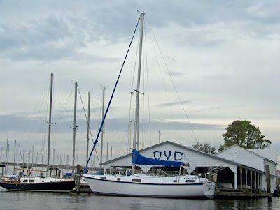
Here, by the way, is a picture of the Hirondelle at her new berth, right on Raccoon Creek at the prestigious Oriental Yacht Club:


-30-